Contact Information
Welcome to our new site!
Thanks for reaching out. We look forward to hosting you.
All online cabin calendars are up-to-date. Please check there for availability.
We aim to return your inquiry within 48 business hrs.
- 193 Camp Maryanne Rd, Mindemoya, ON Canada
- (705) 377-4972
- Email us through this form
Have a Question?
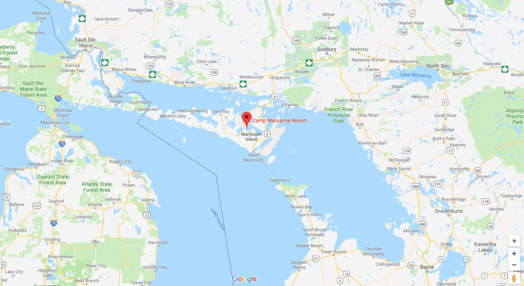
- If you travel from the mainland, you will reach the Island by crossing the historic railway/car swing bridge at Little Current. During the summer season, it opens every hour on the hour to allow boat traffic and all land traffic ceases for a short but enjoyable time, while the bridge opens and closes to allow the boat to pass under it
- Once you cross the bridge, proceed to follow Highway 540. You will firstly proceed somewhat southerly on Manitowaning Road towards Provincial Secondary Highway 540 (Meredith Street in Little Current)
- You will turn left from Meredith Street onto Worthington Street and continue to follow Highway 540. Highway 540 leads to Gore Bay, but you will not go that far. You follow Highway 540 westerly a distance of 18.4 miles
- At that point, you should be in the M’Chigeeng Reservation and encounter the intersection of Provincial Secondary Highway 551
- Turn left, so as to proceed southerly along Highway 551, a distance of 4.2 miles
- You will encounter the Rockville Road, which will intersect Highway 551 from the east
- Turn left onto Rockville Road and proceed easterly 1.6 miles
- At that point, Rockville Road veers to the left and you are at Camp Mary Anne Road
- Proceed another 0.3 miles and you will be at Camp Mary Anne
MS Chi-Cheemaun is the largest passenger/car vessel on the Great Lakes.. When you land at South Bay Mouth, it is a 28.2 mile drive (45 kilometers) to Camp Mary Anne. It should take you between 35 and 45 minutes.
- Check the Chi-Cheemaun Websitefor schedules and fares.
- From the Chi-Cheemaun Ferry docks proceed northerly along Provincial Highway Route 6, a distance of 0.1 miles
- After a slight left deviation, continue northerly along Highway 6, a distance of 7.9 miles
- Turn left so as to proceed generally westerly along Provincial Secondary 542, a distance of 13.1 miles
- At that point, stay on Provincial Secondary Route 542, a distance of 2.5 miles, which should take you to the Town of Mindemoya
- In Mindemoya, you should turn right, so as proceed northerly along Provincial Secondary Highway 541. Proceed a distance of 2.7 miles. You will see that at that point the Rockville Road intersects Highway 541 from the east
- Turn right onto Rockville Road and proceed easterly a distance of 1.6 miles
- At that point, Rockville Road veers to the left and you are at Camp Mary Anne Road
- Proceed another 0.3 miles and you will be at Camp Mary Anne